Trails
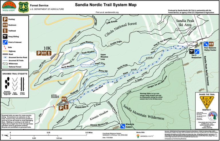
Click on the map, or the download icon below, to download the map. This map is compatible with the Avenza Maps App. Once downloaded to your computer or phone, you may upload the map to Avenza. Avenza will show your location on the map regardless of cell phone connectivity.


Download this PDF Map to your phone to use with the app:
Where are the Nordic trails?
The Sandia Nordic Ski Club maintains approximately 5 miles of trails in the Sandia Mountains east of Albuquerque. The trails are accessible from Hwy 536 (Sandia Crest Hwy) at the 10k and Ellis Trailhead parking areas and also from the Sandia Peak Tram via the Service Road. From the 10k trailhead cross the highway to the south and enter the lower meadow. From the Ellis Trail upper parking area, head east just past the red gate where you will find the north entrance to Sandia Nordic’s Klaus Trail. Klaus will take you south to the upper terminal of the Sandia Peak Tramway. Approximately 1/3 of the way from the north entrance, the Sandia Lower XC loop branches off Klaus to the east and takes you to the 10k parking area.
Be Prepared for Mountain Conditions
The Sandia Nordic trail system courses altitudes ranging from 10,000 – 10,350 feet. The effective oxygen level at these altitudes is reduced by roughly 30% from sea level. Temperatures can vary from -20 F (record low) to 50 F (record high) during the winter skiing months. Average winter temperatures are 15 F to 28 F and are usually pleasant for cross country skiing. Be sure to dress in layers that can be adjusted according to conditions and the degree of exertion. While skiing these trails, it can rain or snow so a wind breaking, water repellant but breathable, outer layer is suggested. Also, sun protection for skin and eyes is strongly encouraged. Sandia Nordic trail users should be aware that high winds are often present on the mountain, which can increase the risk of exposure and hypothermia, as well as the risk of injury or death caused by falling trees and/or branches. Trail users should also be aware that cell phone connectivity is questionable in many areas of the trail system and that carrying a satellite communicator device is highly recommend. The Sandia Nordic trails are not patrolled; skiing the trails without a companion is discouraged.
Please see additional Ski at Your Own Risk information (below).
Information for Skiers
Ski at Your Own Risk
Cross country skiing has inherent risks which include, but are not limited to, exposure to the elements, unanticipated hazards on ski trails (such as fallen trees, ice, exposed rocks, other trail users, grooming equipment, etc.), the potential to be hit by a falling tree or tree limb especially during high winds, and inconsistent quality of the trail due to changing weather patterns and multiuse by hikers, snowshoers, and wildlife. Trail users should also be aware that cell phone connectivity is questionable in many areas of the trail system and that carrying a satellite communicator device is highly recommend. The Sandia Nordic trails are not patrolled; skiing the trails without a companion is discouraged.
The trails that Sandia Nordic Ski Club grooms are still in development. Certain sections of the trail system are steep with limited visibility when turning; there are also sections of the trail system with side hill grades that exceed the USFS cross country ski trail design parameter 8% threshold. Caution signs are in place in many areas of the trail system, however, the Club can not ensure that all sections of the trail have been appropriately signed. Skiers should ski within their own ability and use caution while on the trails, particularly while gaining familiarity with the trail system.
Be prepared to encounter a variety of skiing conditions. The trails include both shaded and sun exposed areas that can range from bare soil or rocks, to slush, to icy conditions within a short distance depending on time of day and season. Club trails are usually groomed for both skate and classic skiing. Trail users should have at least basic familiarity with ski equipment, technique and safety maneuvers.
Currently, there is not a designated direction for skiing. Please be aware of basic trail etiquette when encountering other skiers. It is customary for uphill traffic to give way to downhill traffic. Periodically, skiers may encounter grooming equipment working on the trail. In this case, simply step safely off the trail for machinery to pass.
Sandia Nordic does trail maintenance throughout the year to help level the trails and keep them clear of hazards. The Club invests considerable effort to make the trails as safe as possible but cannot guarantee the safety of the trails or trail users. Skiers who use the trails that Sandia Nordic works to maintain do so at their own risk.
